Development of Guide Material for the Education of Cultural Immovable Heritage Management for Bachelor Students of Geomatics Engineering
Çelik, Mehmet Özgür
Türkiye has a wealth of foundations and their properties, assets managed by the General Directorate of Foundations (GDF) through its geomatics engineers. This article aims to identify the misconceptions of senior undergraduate geomatics engineering students (sample group) about the relationship between foundations and land ownership registered as cultural heritage. It will develop and implement materials to eliminate these misconceptions and evaluate their effectiveness. This study consists of a preliminary, a pilot and the main application. The data collection instruments are an open-ended questionnaire, a semi-structured interview form and conceptual understanding tests. As a result of the analysis of the pre-study and the pilot study, guidance materials on information deficits and misun...
Sürdürülebilir Arazi Yönetimi Altında Türkiye’de Korunan Alanlar
Çelik, Mehmet Özgür
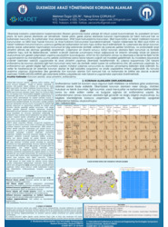
Korunan alanlar; geçmişten günümüze kadar önemini korumuş; tarihi, kültürel, ekonomik, sosyal ve doğal özellikleri nedeniyle korunması gerekli alanlardır. Bu alanların etkin şekilde korunması, yönetilmesi ve gelecek nesillere aktarılması son derece önem arz etmektedir. Artan kentleşme baskısı ve yanlış arazi kullanımı gibi nedenler korunan alanların koruma- yönetim-kullanma sorunlarını derinleştirmektedir. Çalışmaya konu korunan alanlar ve bunlar ile ilişkili taşınmazlar için sürdürülebilir arazi yönetimi uygulamalarında neler yapılması gerektiği konusunda genel bir çerçeve çizilmiştir. Korunan alanlar ile ilgili mevzuatlar incelenmiş, sorumlu kurum ve kuruluşlar araştırılmıştır. Türkiye’de hâlihazırda bulunan korunan alan sayıları ve alansal değerleri sunulmuştur. Tüm bu irdelemeler netic...
Protected area geographical management model from design to implementation for specially protected environment area
Çelik, Mehmet Özgür
urkish National GIS (TNGIS) studies have been accelerated to standardize Turkish land administration after INSPIRE and LADM and to be a part of the e-Turkey transformation process. In the process, one of the geographical data sets transferred from the classical environment to e-government platforms is the protected areas. This study was carried out for a Specially Protected Environment Area (SPEA). The Göksu Delta has been determined as the study area. In the study, an interview form was used as a data collection tool. Then, the geographical data model design of the SPEA was carried out with UML schemes. The most important results obtained from the study are the necessity of preparing UML diagrams for all protected areas together with field experts and integrating them into TNGIS, and the ...